Monthly Archives: October 2013

SKY GAZERS’ DELIGHT: KENYA END YEAR 2013

By Don Pablo

After months of grey skies that inhibited views of the cosmos for earthlings in this part of the world, the clouds have finally dispersed. As we approach summer, the clear skies come bearing gifts for sky gazers to make up for the lost months. It’s late October in Nairobi and a lot is happening in the sky. Between now and the solstice on December 21st, sky gazers in Kenya will see the brightest planet in the solar system reaching its pinnacle in brilliance, a solar eclipse and a potentially super bright comet.

As if sensing the astronomical thirst we have had to endure, the skies have wasted no time in putting up a show for us. Planet Venus has been lighting up the sky as it beams mightily in the west at dusk, living up to its ‘evening star’ moniker. The evening star is the brightest planet visible from earth and the third brightest celestial body after the sun and moon. Venus dominates the western sky and is visible for two hours after sunset before setting in the western horizon. That it’s visible in the early evening sky makes it particularly easy to view.
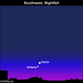
Image

Position of Venus in the evening sky. Antares is the brightest star in the Scorpius constellation (c/o earthsky.org)

Venus has been visible for the better part of the last three months. It was particularly dazzling three nights ago when perched right at the ‘tail’ of the Scorpius constellation, one of the twelve constellations of the Zodiac. Identifying Venus should help you see the Scorpius constellation given their proximity at this particular time in this part of the world. As you can tell from the name, the Scorpius constellation resembles a scorpion as shown in the image below.

Image

Venus (in red) and the Scorpius constellation

Having curtain raised for its more illustrious celestial bodies, Venus leaves the stage for the Sun and Moon to enchant us. On the 3rd of November, the moon will pass between the Earth and the Sun, partially blocking out the Sun and putting on a spectacular celestial show for people who are in the right place to see it. This particular solar eclipse has received a lot of coverage in Kenya and rightly so. The Turkana region offers some of the best views of the eclipse anywhere in the world.

When the Moon passes directly between the Sun and Earth, the usual outcome is either a total or partial solar eclipse. But the event on November 3rd is something of a hybrid. A hybrid solar eclipse occurs when the Moon is almost too close to the Earth to completely block the Sun. This type of eclipse will appear as a total eclipse to some parts of the world and will appear as a partial eclipse to others.

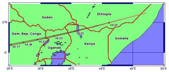
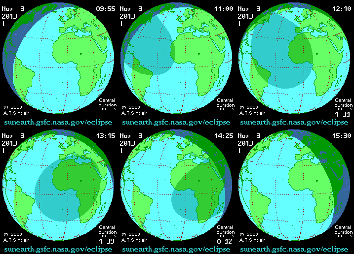
The eclipse path will begin in the Atlantic Ocean off the eastern coast of the United States and move east across the Atlantic and across central Africa.

Image

Turkana region lies directly in the path of the total eclipse (c/o earthsky.org)

Totality will be visible only from a narrow track of earth, stretching from Gabon in the west to Kenya and Ethiopia in the east. In this very narrow path across Africa, there will be a total eclipse when the moon covers the sun completely, with darkness descending and the stars coming out! In every other place of Africa beyond that narrow band of totality, everyone will see a partial eclipse including folks in Nairobi and Mombasa.

Image

Path of the solar eclipse (click to view gif) – c/o sunearth.gsfc.nasa.gov/eclipse

Kenya will be a particularly popular destination for astro tourists seeking to enjoy this rare occurrence. While the eclipse duration locally is only 11 seconds or less (compared to more than a minute in Gabon), the northwest region of Kenya has excellent weather prospects with clear skies expected.

(Please note that it is dangerous to look directly at the sun without the aid of a solar filter to block the sun’s harmful rays. It may cause “eclipse blindness,” a serious eye injury that can leave temporary or permanent blurred vision or blind spots at the center of your view. If you cannot access a solar filter, try get your hands on a welder’s protective glasses. Used camera films aren’t of much help so you might want to reconsider using that as well).

Fast forward to November 28th and newly discovered comet ISON will make its closest approach to the sun. If the comet survives its encounter with the sun, it could be one of the brightest comets in recent memory. Some astronomers estimate that it could even be bright enough to be seen during the day!

The big question mark however is whether the comet will stay intact, or shatter in spectacular fashion. If the comet survives, it will be visible in the early morning and early evening sky and could be nearly as bright as the full Moon. Some astronomers are already calling it the comet of the century.

The end of the year marks the beginning of summer in the Southern hemisphere. On December 21st, the South Pole of the earth will be tilted toward the Sun, when it ‘reaches’ its southernmost position in the sky and will be directly over the Tropic of Capricorn at 23.44 degrees south. This is the first day of winter (winter solstice) in the Northern Hemisphere and the first day of summer (summer solstice) in the Southern Hemisphere.

Given our position on earth, we are lucky enough to witness some spectacular celestial events in the coming weeks. If you are lucky enough to be able to travel to Turkana, savour the moment and please share your pictures and experiences with us. If you can’ travel to Turkana, you can enjoy the sights from the relative comfort of the home. Wherever you may be, enjoy these sensory delights and  marvel at the wonders of the universe.
Categories: Astronomy | Tags: , , , , , , , , | 2 Comments

How Nairobi’s Geography Shapes Our Lives

A little over a hundred years ago, the bustling city that we call home was little more than an uninhabited swamp littered with wild animals. The city of Nairobi came to be when the British took advantage of the last flat area they encountered before beginning their ascent up the escarpment wall while constructing the Kenya-Uganda railway. Where Nairobi stands today, the British pitched camps where they could pause for a breather before embarking on the grueling attempt to ascend the rail track over the escarpment, into the Rift Valley and beyond.

The decision to pitch camp at Enkare Nyirobi, as it was known then, and the resultant growth of the camp into the capital city has shaped and continues to shape the lives of its residents to date.

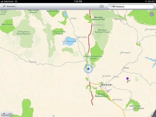
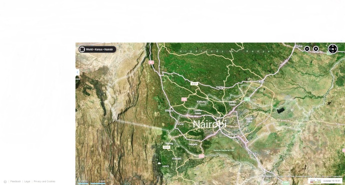
Before proceeding, it’s best to understand the position of Nairobi relative to its surroundings for this piece to make sense. Nairobi lies a few kilometers to the East of the Rift Valley, with the closest distance being the 30 Kilometers to Ngong’ Hills, which forms part of the escarpment.  The map below shows the position of Nairobi relative to the escarpment. The red line is roughly where the escarpment runs.

Image

Nairobi’s proximity to the Rift Valley has lent it a unique geography with the city roughly divided into two halves of varying elevations. That the city is quite limited in terms of acreage only serves to better highlight the striking difference in altitude between its Eastern and Western halves. As you approach Nairobi’s Eastern boundaries from Athi River, you are in a relatively flat area: the Athi plains. This flat area stretches North-South from Ruiru, across Eastlands, Industrial Area, the Nairobi National Park all the way to Rongai in the South.

The city experiences a sudden rise on its western side as the ascent up the escarpment wall begins. This ascent sees Nairobi areas such as Karen, Langata, Ngong’ road, Westlands, Parklands, Gigiri all the way to Kiambu being higher than the aforementioned areas on the eastern side.

The difference in height manifests itself clearly along the low-high divide that cuts across the city, a feature that sees sudden steep ascents/descents in various parts of Nairobi. The slope that marks this divide runs from Rongai cutting across Magadi road near Multimedia University and extends all the way across the National park. You will notice the descent if you’ve been to a game drive at the National Park where you drive from a high area where the offices are located (with lots of trees) to a low flat grassland. The low-high divide is shown in the map below with the black line roughly indicating where the slope is located across the city.

Image

The slope extends past the National Park and cuts across Langata road near Uhuru gardens, hence the elevation as you approach Langata. The cliff face extends beyond Nairobi Dam and manifests itself on Mbagathi road where it cuts across the road near Highrise and extends all the way to Upper hill behind Kenyatta Hosital, KASNEB and Madaraka estate. Along this particular stretch, the railway runs adjacent to the slope. The slope approaches the CBD and can be clearly seen on Bunyala road near NIC Bank and the Railway Golf Club. Uhuru Park is perhaps the most famous stretch of this slope that continues its division of the city along State House road and Kileleshwa to resurface clearly on Waiyaki Way near Chiromo. Along this entire stretch, the average height above sea level increases by up to 100M. Beyond Westlands, the slope is seen in Parklands and runs adjacent to Thika road in Muthaiga past Garden estate and beyond.

The difference in height between the eastern and western side of Nairobi has determined the zoning of the city (hence delineating the affluent and working class areas), the drainage pattern, weather and vegetation in Nairobi.

The higher areas to the West of Nairobi are relatively ‘richer’ than the Eastern half of the city. Thika road and Langata road roughly divide the city into an Eastern-Western half while the Northern corridor – Mombasa Road and Waiyaki Way – divides the city to have a Northern and Southern half. The intersection of these roads near the City center divides the city into four quadrants.

Image

The upper Western quadrant bordered by Thika road and Waiyaki way (quadrant 1) is home to the super rich of Nairobi, Kenya and the region in general. This quadrant contains suburbs like Gigiri, Nyari, Runda, Kitisuru as well as the UN headquarters and high end shopping malls.

The lower Western quadrant bordered by Langata road and Waiyaki way (quadrant 2) houses the upper middle class and includes estates like Kileleshwa, Lavington, Hurlingham and Adams Arcade. The periphery of this quadrant has working class estates like Kawangware while the affluent Karen that borders the escarpment at Ngong’ is also situated at the southern tip of this quadrant.

The lower Eastern quadrant bordered by Langata road and Mombasa road (quadrant 3) is largely filled by the Nairobi National Park with estates like Rongai, South C and Nairobi West being on its edges. The upper Eastern quadrant bordered by Mombasa road and Thika road (quadrant 4) is largely a working class area and an industrial zone. This includes estates adjacent to Thika road like Mathare and Kasarani, estates along Outer Ring and Jogoo roads as well Embakasi and areas near the JKIA. It is also worth noting that the City’s two airports are situated in the relatively flat Eastern half of the city.

The aforementioned slope also affects the drainage of Nairobi. The law of gravity dictates that water flows downhill and with a flat area bordering an elevated one, it is no coincidence that Nairobi was described as a swamp by the British when setting up the city. Water flows rapidly eastwards whenever it rains and upon reaching the Eastern plains, the water spreads out forming a flood plain that is best seen in the National Park. This explains why certain areas of the city experience flooding whenever it rains. The areas that lie adjacent to the slope (indicated in blue in the second map) including Rongai, South C, TMall, Nairobi West, Bunyala road roundabout and Thika road at Pangani experience the worst of the flooding. South C residents will attest to the peculiar phenomenon where it floods in the estate despite no rain falling in the area. Run-off water from Langata, Karen and Ngong finds its way to South C and the National Park causing floods in this flood plain. Indeed, South C has earned the infamous ‘South Sea’ tag due to the frequent floods. The above phenomenon also partly explains the images seen when flash floods caused parts of Thika road to look like a river a few months back. (These areas need enhanced storm drainage, something the British were oblivious to when settling on a flood plain and the Kenyan authorities have done little to address).

While Nairobi’s climate is relatively standard across the city, there are times when the weather fluctuates from one part of the city to another. This ‘micro climate’ phenomenon is influenced by the difference in altitude. Apart from the example of Langata, Karen and South C above, you find situations where it rains in Hurlingham, Kilimani and Kenyatta Hospital but it becomes sunny as you descend to the other end of Mbagathi road at TMall.  The weather is also cooler in the Western side of Nairobi than the Eastern side especially in the morning, typified by the fog along Waiyaki way in the morning.

There’s a similar distinction in the soil and vegetation in the Eastern and Western side of Nairobi. As this map below shows, the higher Western side is ‘greener’ with more fertile soils. This explains why the early settlers had coffee farms especially in the areas adjacent to Kiambu road. This particular area lies at the foot slopes of the Aberdares which forms part of the escarpment.  The large coffee farms were later subdivided towards independence to form the affluent suburbs of Nairobi. Karen estate was also a farm made famous by Karen Blixen’s memoir ‘Out of Africa’.

 NBO 2

Beyond Nairobi towards the Rift, there is a steady increase in height with dramatic change of weather as you approach the peak of the escarpment. This includes areas like Limuru which have an average height of 2200m above sea level with the neighbouring Nairobi being 1800m above sea level. Kinale forest situated 20kms from Naivasha is the peak of the escarpment along the Nairobi-Nakuru Highway before the dramatic descent to Naivasha.

Dip slope .

The distinct diversity in altitude over a small, compact area has given rise to a unique city that has the distinction of being the only city with a park in the world. Rivers, valleys, flood plains, hills, forests, dry areas and views of the Great Rift valley co-exist in this thriving city that is the biggest between Cape and Cairo. I’ll end this piece by giving you all a heads up. While it took me the better part of three years to observation and deduction with a couple of months researching and drafting this blog piece, it will take you a trip to the KICC helipad and information from this blog post to appreciate the unique geography of this city we call home and how it affects our everyday life as Nairobians.

Categories: Best of Panoramicdon, Uncategorized | Tags: , , | 36 Comments

Create a free website or blog at WordPress.com.